Use Global Mapper
to find a school in the United States and display an aerial photograph or map of it.
An important part of natural history research is to accurately record the position of your observations.
Here we help you learn how to use latitude and longitude coordinates. This coordinate system is widely used
to reference any location on the face of the Earth. You should know that
Latitude and longitude are measured in degrees (°), minutes (') and seconds (").
There are 60 seconds in a minute, and 60 minutes in a degree.
Latitude and longitude use a grid system of lines based on the cardinal directions: North, South, East & West.
Because magnetic north moves over time, you need to calibrate compass readings slightly before using them with grid systems on maps.
Latitude measures position north or south of the Equator,
an imaginary line running around the Earth that has a latitude of 0 degrees.
Latitute values range from 0 degrees to 90, either north or south.
The North Pole is latitude 90 degrees north; the South Pole, 90 degrees south.
Longitude measures position east and west of an imaginary line called the
Prime Meridian that runs through the Royal Observatory in Greenwich,
a metropolitan borough of London, England, located at 51° 28' 38" (or 51.477222°) of latitude north of the Equator (see
map).
The Prime Meridian has longitude 0 degrees.
The International Date Line is the on the opposite side of the world to Greenwich. Because there are 360° in a circle,
the International Date Line is both longitude 180° east and 180° west of Greenwich.
Many computer programs require that latitude and longitude be expressed as in decimal values of degress rather than minutes and seconds.
Use the following formula to convert from degrees, minutes & seconds to degress in decimal format:
degrees.((minutes+(seconds/60))/60)
They also require that southern latitudes and western longitudes are expressed as negative values. Thus, the South Pole becomes latitude -90°
rather than 90°S or 90° South.
How to build & display maps
Our Global Mapper
allows you to build and display maps of anywhere in the world.
Its Find Place tool
allows you to find most of the schools in the United States and display an aerial photograph of them.
The Website at Missouri Botanical Garden
also allows you display maps of the world and of the USA on your browser.
With this software, you can plot points on your maps and learn how to use latitude and longitude coordinates.
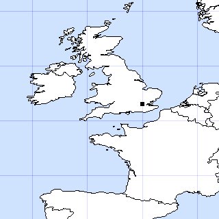
See
example
of a map showing the location of Sams Farm in Clarke County, Georgia, one of the Insect Diversity Project's study sites near my house.
The URL to generate this map is
http://mobot1.mobot.org/website/map.asp?Layer11=on&Layer1=on&SubmitButton=Refresh+Map&specimen=Sams+Farm&iht=320&iwd=320&ht=10&lat=33.9&lon=-83.4&mark=33.9,-83.27
Try to modify this URL to display the location of your school or study sites.
Substitute your latitude & longitude values, respectively, for the URL's values of 33.9 and -83.27.
Be careful to change BOTH values of 33.9 for your latitude and similarly both values of -83.27 for your longitude.
The first one refers to the center of the map; the second to the point you wish to plot.
Adding ;33.11,-83.22 at the end of the URL adds an additional point.
Thus, you can add multiple points, each separated by a semicolon.
Changing the values "ht=10" from 10 to other values will change the scale of your map.
Deleting "&mark=33.9,-83.27" will produce a map without a point.
Note that the negative longitude means that Sams Farm is west of Greenwich. If you want to plot a point in the Southern Hemisphere,
you will need to use a negative latitudinal value.
When the map appears, you can change its appearance by clicking the buttons on/off under Layer List and then clicking on "Refresh Map."
Enjoy!!!
John Pickering
12 August, 2001